As the title of my blog suggests, my main priority in an adventure is doing something that is point-to-point, rather than say a loop (less good) or out-and-back (the worst). As a result, my ‘A’ race for this year was the Great Southern Endurance Run 183km, known as a (hundred) ‘miler’ despite it being 22km longer than the miler distance. It was much to my dismay that following a fortnight of frequent and sometimes heavy snowfalls in the Victorian Alps, the word came through that my long-anticipated point-to-point from Bright to Mt Buller had become a dreaded out-and-back, from Harrietville to Mt Speculation to Harrietville. I would now have to run 85km, over some of the roughest mountains in Victoria, and then turn back? Fortunately the race would have a similar vertical drop and be only 12km shorter, which made it steeper and in some ways tougher than the original course.

Click the image to go to my Strava activity
I entered this race back in September 2018, having applied about 18 months before race day. When I applied to enter, I had done three 50-km and two 50-mile races, and was preparing for my first 100km, the GOW100. This was a huge step up for me, so my plan was to run three 100km-races in the lead-up, which I wrote about here, here and here.
The original plan had been for my adventure partner Jackson to fly down to Melbourne so he could pace me through the middle 80km of the race. However, with the course change he was now looking at what we thought was a 110km stretch of pacing, later revised down to 95km. Given a few knee problems and the increased pacing distance, he decided to accompany me over the last 38km instead, during the part in which I would be most exhausted.
If you want to see a replay of the race from our satellite trackers, check out the link here. Click the clock icon up to top left to replay the race. In short, I came in third place in 33 hours 45 minutes, with 10,200 metres of climbing over 171km.
The Out
We lined up just before 5am in the dark in Harrietville, and before long were running towards Bon Accord Spur to go up almost to the top of Mt Hotham. I was racing with poles to preserve my legs, and found I was out-climbing the others, although not by much. Jo Dorph, Burt Kennedy, Ryan Lowe and I broke off from the front of the field and powered up above the treeline, where it felt below zero with windchill in the early morning light. Three of the four of us put on our mandatory high-vis vests and jogged down the Hotham Road from the Razorback turnoff to Mt St Bernard. I let first and second get ahead because I didn’t feel like running faster than the 4:50 min/km pace I was already doing!

Just a bit apprehensive

Bon Accord Spur, at the treeline
I pulled into the aid station and was met by my large support crew: Audrey, Jackson and my parents. There I had the full service: sunscreen on all relevant body parts, food top-ups for the next stage, food virtually shovelled into my mouth, water refills including electrolyte tablets. So efficient was this operation that I left at the same time as Jo and Ryan, despite arriving over two minutes later. Unfortunately, I tried to leave without my all-important poles and turned around to multiple shouts for my attention and Jackson holding the poles for me. Thanks guys!
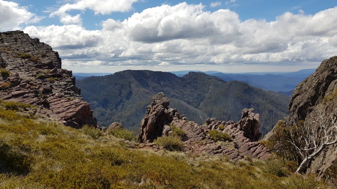
I headed over one of the two steepest parts of the course: the Twins and Mt Murray. On the Twins there is no track, just an open route with pink tape to guide us for the race. The gradients over this section are about 50% (or 26° – thanks high school maths for making the conversion possible) and I climbed with Jo in first place, but let him go on the descent as I didn’t have the same confidence on the steep, rocky terrain.

Dreaming of skiing coming off the Twins. Thanks The Eventurers for the photo!

Morning lines, the Twins. Note the pink marking tape on the tree – I was further away from the photographer than I should have been!
Before I knew it I was at the Selwyn Creek aid station, 38km into the race. As I left I saw Burt in 3rd place coming in behind me, so I knew the pressure was on. I made my way through the Barry Mountains along 4WD tracks forming part of the Australian Alps Walking Track (AAWT), which goes 650km from Walhalla in Gippsland to the outskirts of Canberra. The ridgeline we followed was not flat and we had to contend with a few 4WD groups; I tried to let them past without actually stopping but it wasn’t easy. The temperature was still pleasant except in direct sunlight where it was on the warm side.
The next section was Mt Selwyn, which had been marked on our course guide as ‘scrub fight’. This is slower than other categories of trail, including ‘bush run’, ‘bush walk’, ‘scrub walk’ and ‘rocky run’, but possibly quicker than ‘rocky walk’, depending on conditions. I had been preparing myself for this section, but found it over mercifully quickly, and not as bad as the kind of scrub-bashing we have to do in rogaining.

View from Mt Selwyn with Hotham on the horizon
At about the 7-hour mark (midday Friday) I hit a 10km+ gravel road section where we detoured from the AAWT via the Riley Hut aid station. This time my legs were a bit less cooperative than descending the Hotham Road, but I still managed to hold close to 6:00 min/km. It was around here that I found out that one of my water bottles was leaking through the lid, while the other lid popped off at one point and squirted flavoured water all over my face. Lucky no one was around to witness the indignity, but I guess I am telling the internet about it now.
At the bottom I was unsure if the aid station was actually at Riley Hut and there was no sign or course marking at that point to tell us where to turn off. When I eventually got there I found two first aiders, but my drop bag wasn’t there and neither was the set-up for the whole aid station. Fortunately the bags arrived while I was there, but they were too late for the leader. Thanks to Julie for giving me some food and a replacement water bottle!
We were down at the second-lowest point of the course, so there was a substantial grinding uphill section after, where I decided to hill-bound with my poles. Before long it was through a glorious tunnel of wattle through the ridge-top mountain ash forest as I entered the Razor-Viking Wilderness, where there is limited signage and in parts even more limited track maintenance. More parks funding please!

Wattle forest on the way to the Viking
There were several sections that were rough because of small sticks and rocks on the ground which meant I had to concentrate, and other sections where the forest had been burnt during one of the catastrophic fires in the 2000s and the dead alpine ash trees had fallen over, leaving us with a giant game of pick-up sticks where the sticks were logs and I had to make the agonising decision of whether to vault over or duck under, hoping each time that I would make the choice that fatigued my muscles least. Other sections were just plain steep, rocky or otherwise overgrown, and it made for slow going.
A note on fires: a lot of the course was severely affected by bushfires in 2003, 2006-7 and in some parts 2009. Other parts of the Victorian Alps were also burnt earlier this year. As of 2015, 84% of the alpine ash forest in the Australian Alps had burnt since 2002. While fire is an important part of much of the landscape and is necessary for some species to germinate, the frequency and intensity of the fires over the last two decades has been a massive environmental problem. The two biggest and most impressive species in tall mountain forests, alpine ash and mountain ash, need 20 years to produce seeds that can be cracked open by a hot fire to re-germinate. In recent years some areas have been re-burned before they can produce new seeds. This means that, without re-seeding by helicopter, which has happened in some areas, these forests are at risk of being lost in the long term, replaced by wattle and other species. Many of the alpine forests are therefore one more hot fire away from being lost forever – treasure them while they are still there and vote accordingly! Have a read of this document which explains the problem.
Back to the race, and to the climb of the fearsome Viking. I could see a large forested wall getting ever-closer, and when we got to it the slope involved me using tree branches to pull myself up the ridiculously steep walking track, hoping not to slip back down on the loose dirt. By this point I realised I was running a bit short of water and had a lot of extremely tough terrain to go – I started rationing myself despite the sun making me constantly thirsty. The route then went under still more fallen trees and around the sides of cliffs before eventually climbing up onto the 1500m high summit, which I reached at about 3:50pm. I was glad for the extremely frequent marking as the track was faint; kudos to the course markers!

Viking summit ridge
Razor from the Viking – the next destination

Mt Buffalo (left) and possibly Bogong (behind right) from part way up the Viking
After a few seconds – yes that’s all I was allowing myself – to take in the view, I started the descent off the other side, which had an average gradient of only 40% but also included a wire ladder strung up down a rock chimney, to help us descend through the nearly unbroken line of cliffs on the Viking’s western face. This was the first time I had put my poles away as I knew I needed my hands for the descent.
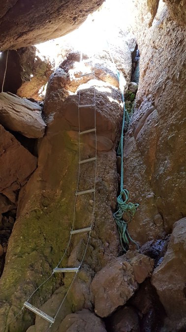
The infamous wire ladder

West face of the Viking showing the cliff line
Next it was up over the Razor, where I was glad it wasn’t raining and slippery as there was quite a lot of exposed rock. By this point I was looking for any flowing water I could find, but there were only damp patches that were not enough to drink out of. Then it was over the aptly-named and overgrown Mt Despair, where the chest-high and scratchy scrub really tore into my legs, until I decided to put on Goretex overpants and power through. On the climb up to the aid station near the turnaround point at Mt Speculation, I decided to slurp some water from a trickle on the embankment next to the track. I got a bit of dirt in my mouth but it was worth the brief stop. This was even more so considering that all the other bits of running water were on the track itself, and I didn’t feel like drinking straight off a road.

Summit ridge of the Razor
On the approach to the aid station I saw the leader, Jo, returning down the hill. It became apparent that he had put some serious time on me and there was no way I was catching him. I reached the Mt Speculation aid station and once again discovered that it wasn’t set up yet – I had been too fast again! Fortunately there were first aiders there once again and my drop bag was there, so I filled up with a bit of water and walked the final kilometre up to the turnaround point on top of Mt Speculation. I was glad to reach the summit in daylight (just before 7pm) having run 86.5km in under 14 hours. I did some quick maths – I could meet my ‘fast’ target time of 31 hours and still be three hours slower on the return leg, which sounded do-able. Little did I know what was in store.

Feeling fresh (?) on top of Mt Speculation

Evening rays over Buller

Mt Howitt and Mt Buggery. The original course went over here.
I had a longer stop at the Speculation Aid Station the second time, where I enjoyed instant noodles, and Up and Go, chips, lollies and other delicacies. Team Moxham had arrived by this point but I hear the vibe really got going in the following hours, with one of the most lavish aid stations around set up overnight. Having gone through a fairly tough period of thirst, it was nice to be fully fed with warm clothes and a headtorch on, ready for the night at hand and the return journey.
The Back
On the way down towards Mt Despair I was able to suss out the rest of the field. While Burt wasn’t too far behind and was at the aid station with me, it was reassuring to see that there was a fair gap to the rest of the field, as I gradually passed everyone who hadn’t already been pulled out for missing cut-off times. I put on my overpants before the start of Mt Despair this time, and decided to put away my poles for a second time, as I felt good and wanted to enjoy the actual running more. I powered through the scrub of Mt Despair and felt great as darkness fell. Unfortunately it also started to drizzle, which meant on the open rock faces of the Razor I was paying extra attention given my concern earlier in the race with slippery exposed bits. I was glad to have the occasional blinking green light marking the trail at this point, and itt was nice to have brief chats with those runners still on their way over, even though I avoided looking at their faces so as not to blind them with my head torch.
Just before the ladder on the Viking I noticed Burt very close behind me, but I soon lost him again. Turned out he got to the top of the Viking and then lost the track for a while! After an entertaining slide and swing-off-branches down the steep, eastern face of the Viking, I was back through the pick-up sticks and eventually onto tracks. During this period Burt was catching me on the downhills but I was comfortably putting time on him during the uphills. Did I mention that at no point in the race, including both the hot sunny bits and the cold drizzly bits, did he have a shirt on?
I had now done the roughest bit of the course twice and was faster on the way back, having taken about five hours to get to Mt Speculation from Van Dammes track and five hours to get back, but including a break. I was 105km down, had been running for 19 hours (it was midnight), and was feeling good for the final 66km. There were two warning signs, however:
- my gut had started to play up by this point and I had already had one squat in the bush, which isn’t ideal during a race; and
- I was not running the long road descent back to Riley Hut Aid Station particularly well, in fact my descent speed was roughly the same as my climb speed on the way out.
This time at Riley Hut there was a full aid station and raging fire going and I tucked into some food, although probably not quite enough in hindsigt. Again, my gut was front of mind and I didn’t want to overload it. I left this aid station ahead of Burt and didn’t see him on the long slog up back to the AAWT/Selwyn Track. I still felt pretty good walking with my poles and was holding a good speed, but I was concerned that my legs, at 110km and nearly 20 hours in, weren’t feeling like running. This suspicion was confirmed when the road flattened out for a gruelling 5.5km flat stretch, and I found running at more than 6km/h a serious challenge.
By this point it was about 2am, I couldn’t run, I needed to and did squat by the track again, and I was starting to get sleepy. I am pretty bad at staying awake overnight, and at various points as I started climbing back up Mt Selwyn over the following two hours (until 4am) and 9.5km, a few alarming things happened.
- My vision became blurry as I took microsleeps while running, which sometimes left me swerving sideways and leaning on my poles to avoid falling over.
- I started conceiving of each leg as a personality separate from me. As such, I found myself asking each leg for cooperation on each step.
- I thought my digestive system was a separate person, and most alarmingly of all, I started calling it Sarah. As in, ‘I think Sarah needs feeding, she’s feeling hungry and complaining’.
Of course, I was not willing to give Sarah the food she wanted at all times given my gut, and so keeping enough nutrition up through gels was a big challenge. I think the name might have come about because there was a Mt Sarah listed on the map nearby, which in my state I had confused with the Mt Selwyn I was climbing over. Some of the logs on the side of the trail did look a lot like signs or other human structures, but I fortunately didn’t experience the hallucinations that are common among GSER competitors.
Knowing my speed had dropped to 4.5km/h, I started thinking about it taking another 10 hours for the 44km to go, and suddenly I seemed a very long way off finishing. Aside from the physical pain in the legs, I had felt pretty good mentally, but that was at risk of shifting big-time. Fortunately, it got light during the next 5.5km and nearly 1.5 hours to the aid station, and before long I could hear my dad screaming encouragement from part way up the hill down into the aid station. At the bottom was the very welcome sight of Audrey, Jackson, my parents and Mel, the latter of whom served me a plate of potato gems. By this point my fancy Salomon racing shoes were full of holes, so I did a shoe change, put away my head torch, and started walking/running with Jackson, who would pace me for the last 38km. This thing suddenly seemed more manageable, and Sarah had retreated into my memories!
Hard not to be uplifted by a morning like this
Jackson was an extremely patient pacer, knowing that I couldn’t really run but providing just enough suggestion that made me want to try jogging where I could. He looked for the pink ribbons so I didn’t have to, and kept me distracted with our usual adventure conversation: politics, the environment, work and more. Despite the sadistic climbs over the Mt Murray and the Twins, I was still able to descend at an OK speed, although my running was more of a preying mantis walk (see first video below).
The Preying Mantis
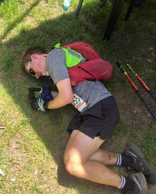
Feeling less thrilled than Jackson (part one)
Feeling less thrilled than Jackson (part two)

Definitely a grimace, not a smile
Before Mt St Bernard I had some company from Brett, with whom I’d done some training, and his dog Arlo. The St Bernard aid station was great: I got some medical attention for my chafing, some sunscreen, lots of watermelon and a pep talk for the final 22km.
The Hotham road was somewhat arduous and went forever and had a fair bit of traffic. Jackson and I resolved to run for the interval of two snow poles then walk the equivalent distance, but I ended up volunteering to jog even further, even though it probably wasn’t more than a fast walking pace. Eventually we were on the Razorback and off down Bon Accord Spur, where I let Jackson run off to experience snow, in the form of an old snow patch, for the first time this year (he lives in Darwin). Needless to say that on the way back from jogging the little diversion he managed to get in front of me.

The Bon Accord descent was substantially harder than the climb the previous morning, and I was surprised to discover the flat bit in the middle wasn’t towards the bottom as I’d remembered, and we still had a lot of descending in hot sun to go. I also realised I had forgotten to sunscreen one arm, so fashioned some sleeve protection out of a buff and a rubber band. During this section Jackson kept reminding me to eat, and reluctantly I would get down a third of a muesli bar before giving up, prepared just to burn fat for the rest of the run. I also decided that the spur wasn’t particularly scenic, mainly due to the multiple fire it has seen recently. I was glad Jackson saw the snake and not me, because I wasn’t sure I would have had the energy to jump out of the way. The thought did cross my mind that if I got bitten by a snake at least I wouldn’t have to run any further.
Razorback track with Jackson’s snow patch
The creek down the bottom with 5km to go was some welcome relief from the heat, but I was worried I didn’t have the mental energy to spend over an hour slogging it out on the flat (well, undulations) to the finish. The solution was to find some physical energy to run so it would be over quicker, which I did! I ended up knocking off the section in just under an hour, and before I knew it I was 800m from the finish, running almost at 6:00 min/km or 10km/h. I crossed the line, found that I was too tired to cry, and curled up into a ball in the finish area. After 171km and 10,200 metres of vertical climb and descent, I was done, in 33 hours 45 minutes and third place in my first ever miler! Burt had gained two hours on me and was asleep and possibly delirious nearby; I was able to get my battered feet checked out before I went in the cool river to wash. Jo had finished a massive 3.5 hours in front of me, so well done to him for a fantastic race.

0.01% of the race to go!
I had been looking forward to a lie down for quite at least 12 hours
Epilogue
Thanks to Jackson, Audrey and my parents for enduring two nights of ridiculously early wake-ups (including, I’m told, much angst over when I would get to Selwyn Creek and how early they would have to leave Porepunkah to catch me in time), and Jackson for spending almost 9 hours with me while going a measly 38km. Thanks also to the Kovacs family, particularly PK, for offering us their loft in Porepunkah for a night and ending up having us for three nights when the course changed.
Thanks also to Sean, Mel and their team, who invest a heap of money, time and effort in the race to bring it to life, even if it wasn’t quite what I had signed up for! Hopefully in two years’ time there will be the opportunity to run the full course. I note that only a week later the Alpine Challenge 100 mile race suffered a course change because of… bushfires on Mt Bogong.
My recovery went surprisingly well this time; I found myself fronting up to the Law Institute of Victoria 8km fun run just over 48 hours later and running two laps of the Tan Track to come third overall! Not the ideal recovery and I am refraining from running for a little while, but during the race I noticed how easy everything felt in comparison to descending the Twins or Bon Accord Spur.
My next races are relatively short: 56km at the Two Bays Trail Run in January and 43km at Roller Coaster Run in April. I haven’t picked my next ‘A’ race yet but am open to suggestions!
